America > Falkland Islands: Weather, Map, Costs and Travel Guide

Falkland Islands : When and where to go?
Click on a city for complete climate and weather tables
| Town | Jan | Feb | Mar | Apr | May | June | July | Aug | Sept | Oct | Nov | Dec |
| Port Stanley |  |  |  |  |  |  |  |  |  |  |  |  |
Falkland Islands: Climate & Weather
The climate of the Falkland Islands is of the subarctic oceanic type, and temperatures vary on average between 5 ° C in winter and 22 ° C in summer, but can go down to -1 ° C, with winds Violent, and frequent rains.
It is better to visit the archipelago in summer, from December to April (the seasons are reversed) even if you must imperatively plan a wax!
Weather today

Rain
Wind: 21 km/h
Precipitation forecast: 9 mm
> Full report and 7-days forecast
Data updated at 08:41 (local time)
At that time, the weather was:
 8 °C / Mostly Cloudy
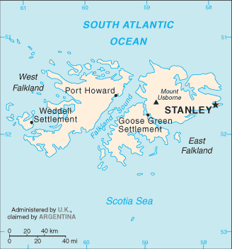
Falkland Islands: Map

Sponsored links
What to do in Falkland Islands
On the coasts you will observe colonies of penguins, and, crossing the moor in 4X4 or during a hike, you will cross flocks of sheep everywhere; You will admire the carved coastline, the cliffs and the lakes, the beaches of white sand; On the island of Sea Lion, there are seals and elephant seals as well as a large number of birds; You may be able to spot an orca and its small, dolphins playing in the ocean and albatrosses.
On the flora side, we see especially heath and a grass specific to the region, the tussock, can form clumps almost two meters high.
Falkland Islands: The basics
The current currency is the Malvinas pound, aligned with the Sterling pound.
You will be able to land at Mount Pleasant Airport, about fifty kilometers from the capital Stanley. To go on the spot, it is better to have a 4X4 outside the main road circuits: watch out for the mined areas! The islands are connected by air.
Health: No special risk, if not cold, for warm and waterproof clothing.
Security: everything is very calm, you will not run any danger!


