In the 1960s, the Aral Sea spanned 66,000 $km^2$ across Central Asia, straddling the border between Kazakhstan and Uzbekistan. Once the world’s fourth-largest lake, it was a lifeline for millions. Today, this vast body of water has lost 90% of its surface area, transforming the region into a bleak landscape of salt and sand. This ecological disaster—one of the worst of the 20th century—stands as a haunting reminder of the cost of unsustainable resource management.
A Saltwater Oasis in the Heart of Asia
The name “Aral” comes from the Kazakh word for “island,” a nod to the thousands of islands that once dotted its waters. This saltwater lake sat in a vast depression amidst the desert, fed by two mighty rivers: the Amu Darya to the south and the Syr Darya to the north. Originating in the Pamir and Tien Shan mountains, these rivers used to pour roughly 60 $km^3$ of water into the sea every year.
In the early 1960s, the region was thriving. Port towns like Aralsk in Kazakhstan and Moynaq in Uzbekistan were bustling fishing hubs, harvesting tens of thousands of tonnes of fish annually. Around thirty different species, many found nowhere else on Earth, called these waters home. The sea also acted as a natural climate regulator, buffering the desert heat and supporting local agriculture.
Soviet Ambition and the Great Diversion
The decline began in the 1960s when Soviet authorities decided to ramp up cotton and rice production across the Central Asian steppes. To turn these arid deserts into “white gold” plantations, they diverted the two main rivers to irrigate some 8 million hectares of crops.
The impact was swift and devastating. By 1986, the combined flow of the rivers had plummeted from 60 $km^3$ per year to just 1.3 $km^3$. The shoreline began to retreat rapidly in the 1970s, with water levels dropping by 14 metres. By 1989, the sea split into two: the North (Little) Aral in Kazakhstan and the South (Great) Aral in Uzbekistan. By the turn of the millennium, half of its total surface area had simply vanished.
A Catastrophe with Many Faces
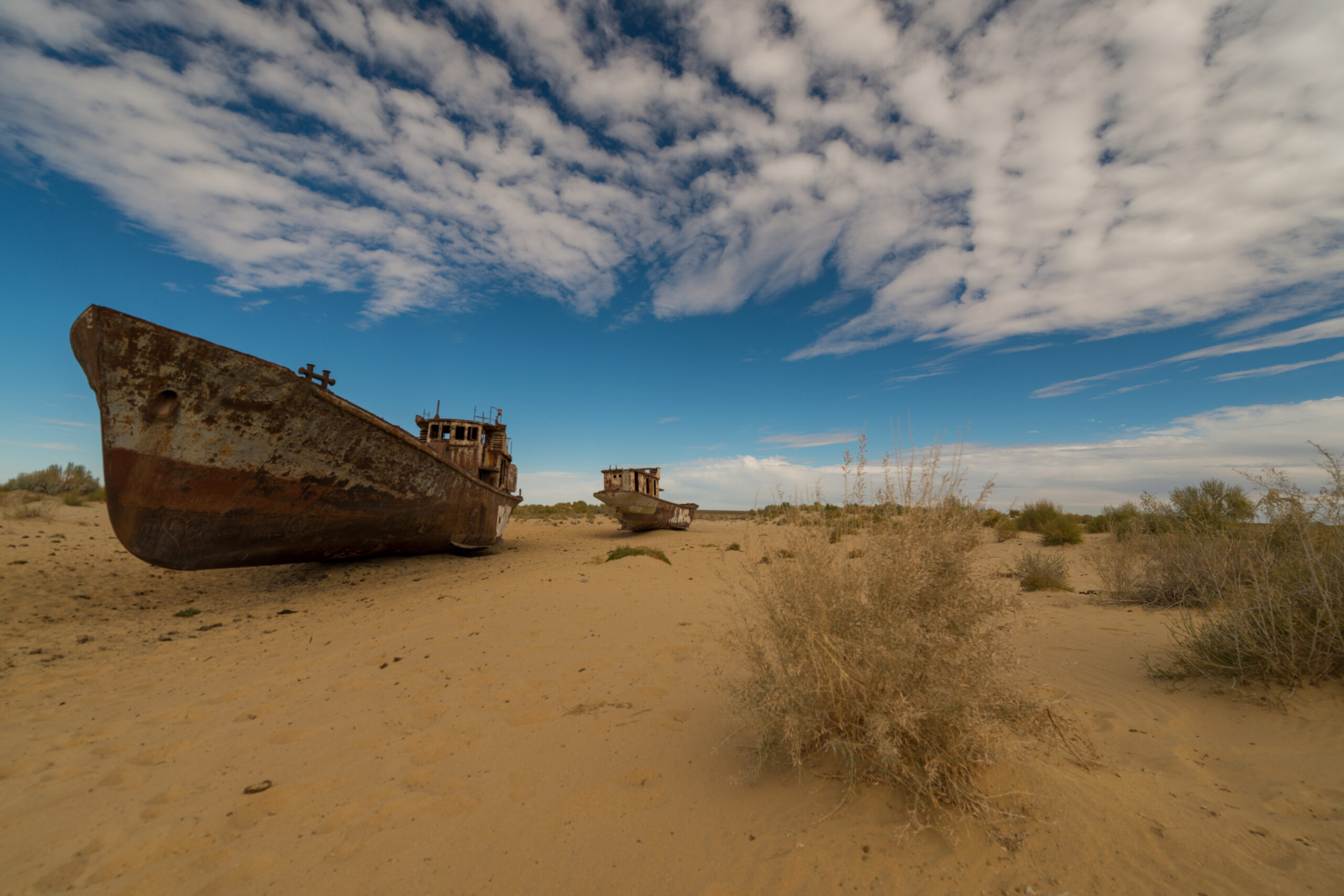
As the water evaporated, the salinity tripled, making survival impossible for most aquatic life. Of the 28 endemic species once found here, only two survived. Fishing trawlers were left high and dry, stranded in the sand kilometres from the receding tide. Today, Aralsk sits 18 km from the shore, while Moynaq is separated from the water by over 100 km of desert.
The exposed seabed, now known as the Aralkum Desert, is a source of toxic dust storms. These winds carry salt and chemical pesticide residue across hundreds of kilometres, contaminating the soil and causing severe health crises, including respiratory diseases, cancers, and tuberculosis. Tragically, the region’s infant mortality rate remains among the highest in the world.
Economically, the area collapsed. Fish processing plants shuttered, sparking a mass exodus of the local population. Entire villages were abandoned, and Aralsk’s population plummeted from 65,000 to fewer than 30,000.
A Glimmer of Hope in Kazakhstan
In 2005, Kazakhstan took a stand against the decline by building the Kokaral Dam, funded by the World Bank and oil revenues. This 13 km concrete dyke separates the North Aral from the rest of the basin, allowing the Syr Darya to replenish the smaller northern section.
The results have been remarkable. By 2006, the fishing industry had already begun to return. In early 2025, Kazakh authorities reported that 2.6 billion cubic metres of water flowed into the North Aral in 2024 alone, cutting salinity levels fourfold. The water is rising, and several fish species have successfully returned.
Kazakhstan is also pushing ahead with the Oasis Project, launched in 2024 in partnership with USAID. This $1.35 million initiative focuses on planting saxaul—hardy shrubs that can stabilise the sand and prevent toxic dust storms. With a 78% survival rate, these plantations offer a tangible way to fight back against desertification.
The View from Uzbekistan: A Stark Contrast
On the Uzbek side, the outlook is much bleaker. Uzbekistan still relies heavily on the Amu Darya for cotton irrigation, leaving the South Aral with almost no inflow. The southern portion has largely dried up, leaving behind only a few isolated, hypersaline basins.
While reforestation efforts are underway to slow the desert’s advance, a full restoration of the southern sea seems unlikely. However, the European Investment Bank is preparing a €100 million investment plan to improve irrigation systems and reduce the staggering amount of water currently wasted.
Visiting the Remnants of the Aral Sea
Despite the tragedy, the region has become a destination for travellers seeking “dark tourism” and surreal landscapes.
- Moynaq: Accessible from the city of Nukus in Uzbekistan, it is home to the famous ship graveyard, where rusting hulls lie scattered across the sand. A local museum provides a sobering look at the history of the disaster.
- The Experience: Many tours offer overnight stays in yurts near the remaining water, allowing visitors to witness the scale of the void.
- The Ustyurt Plateau: This area offers stunning ochre-toned canyons for those interested in photography.
Travel Tip: The best times to visit are Spring (April to June) and Autumn (September to October). In the height of summer, temperatures regularly soar past 40°C.
The Aral Sea remains a powerful symbol of the limits of nature’s endurance. While Kazakhstan proves that partial recovery is possible, the Great Aral in Uzbekistan risks disappearing forever, leaving behind a toxic desert and a fragile legacy.

Hello! I’m Ben Fischer, a travel enthusiast who has journeyed far and wide to bring you unique and inspiring stories. Each destination is a new adventure for me, a chance to explore diverse cultures and share unforgettable experiences.
In my articles, I take you beyond mere descriptions of places. I share the encounters, special moments, and anecdotes that make each trip unique. My writing is an invitation to see the world through my eyes, blending practical tips with personal insights.
As a lifelong traveler, I approach each journey with respect and curiosity, eager to uncover the stories hidden in every corner of the globe.